Kebnekaise, Sverige

Bestegs: 2005-07-13 kl 10:15
Altitud: 2103 m     67°54´N 18°31´Ö


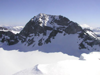
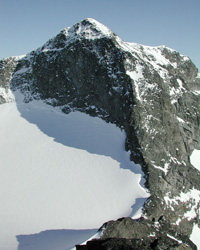
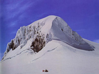
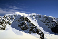
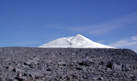
Kebnekaise is the highest mountain in Sweden, thus being is the natural high point in the northern mountain region of Sweden, ranging from Abisko to Sarek. The summit is a glacier, thus the height will vary dependent on the map and the year. The height 2103m is derived from the detailed Kebnekaise map.

Two tourist trails lead up to the summit - Østra and Vastra leden (east and west route). The western trail is the public trail - no difficulties besides the length, while the eastern trail requires some degree of climbing, but the route is much shorter. The east route is guided from Kebnekaise fjellstation every morning, if weather permits. The route description below will cover both routes. Vierramvare is part of the west route and is the only uphill you will encounter when going down the west route. Tuolpagorni is an option for those hungry for more great views, lying next to Vierramvare on the west route.

Halti, Finland

Bestegs: 2005-07-14 kl. 17:00
Altitud: 1328 m     69°18’N 21°16’Ö


These mountains are located in Lappland, where Finland and Norway share border. Raisduottarhaldi is a Norwegian mountain, being the highest in this area. Halti - highest in Finland - is a spur of Raisduottarhaldi, on the country border. Ridnitsohkka is the Finland's 2nd highest mountain, and the highest mountain fully inside Finland.

Halti attracts a lot of hikers, being the highest in Finland, and the main hiking trail runs from Kilpisjarvi in Finland. This hike normally takes several days with overnight stays on huts along the way. A much shorter alternative, is to reach Halti from the Norwegian side, and this is the trail described in this document.

This mountain area is a tremendously large boulder/small rock area, without a single trail. Only the main trail from Kilpisjarvi has cairns showing the way. You will not see reindeer up here. The mountains have for the most very rounded and gentle shapes, with some occasional steeper faces.

Møllehøj, Danmark

Bestegs: 2005-07-15 kl. 20:30
Altitud: 170,86 m    55°58’N 9 °50’Ö


Møllehøj er Danmarks højeste naturlige punkt med sine 170,86 meter. Den er
ca. 10 cm højere end den naturlige overflade i Yding Skovhøj. Ejer
Baunehøj er det tredjehøjeste naturlige punkt med 170,35 meter. Det kan
ikke afvises, at der findes et punkt under den nye Ejer Baunehøj, hvis
naturlige overflade er nogle få cm højere, men ikke af en størrelse der
kan ændre på rangfølgen. Lindbjerg er det fjerde højeste punkt, efterfulgt
af Margretelyst SØ og Vistofte.

Konklusion

Danmarks højeste terrænpunkt er bronzealderhøjen Yding Skovhøj (midterste
gravhøj) med 172,54 meter, mens det højeste naturlige terrænpunkt er
Møllehøj med 170,86 meter. Begge højder er opgivet i DVR90.

Forskergruppen som offentliggjorde disse målinger 28. februar 2005 bestod
af:Professor Henrik Breuning-Madsen, Geografisk Institut, Købehavns
Universitet Arkæolog Mads Holst, Nationalmuseet Sektionsleder Sigvard
Stampe Villadsen, Kort & Matrikelstyrelsen

Andre høje punkter i Danmark (udvalgte):

Rytterknægten - Bornholm 162 meter Bavnehøj - Them 153 meter Sorring
Låddenhøj - Sorring 148 meter Himmelbjerget, Jylland 147 meter Aborrebjerg
- Møn 143 meter Ravnebakke - Bornholm 142 meter Tangen - Gl. Rye 142 meter
Ørringe Bakke - Bornholm 141 meter Tranebjerg - Brande 138 meter
Møllebjerg - Billund 137 meter Møgelbjerg - Salten 137 meter Agri Bavnehøj
- Molsbjerge 137 meter Knøsen - Dronningelund Storskov 136 meter
Kongsbjerg - Møn 135 meter Stabelhøje - Molsbjerge 135 meter Bavnehøj -
Brædstrup 133 meter Frøbjerg Bavnehøj - Ørsted, Fyn 131 meter Lysnet -
Langå 131 meter

Galdhøpiggen, Norge

Bestegs: 2005-07-17 kl. 11:40
Altitud: 2469 m     61°38’N 8°12’Ö


Galdhøpiggen is the highest mountain in Norway and Scandinavia, 2469m above sea level. The mountain attracks large crowds of hikers every year, and is probably the most visited mountain in Norway. The view from the summit towards glaciers and hundreds of other wild and rugged Jotunheimen peaks, is spectacular. A stone hut is located on the summit, and a warm drink and chocolate could be purchased if the hut is manned.

Even in summer, the weather on the mountain can be severe. Even on the finest day, you may experience the coldest winds. In other words, one should always dress accordingly.

Keilhaus Topp and Svellnos are two smaller humps you pass over, on your way from Spiterstulen to Galdhøpiggen.

Hvannadalshnúkur, Island

Bestegs: 2005-07-19 kl. 13:52
Altitud: 2119 m     64°02’N 16°40’V


Hvannadalshnúkur is the highest point on Iceland, located on the Öræfajökull glacier, a southern spur of the largest glacier in Europe - Vatnajökull. Vatnajökull was recently covered in the international newsroom due to the eruption near Grímsvötn Dec 18 1998. Öræfajökull connects to Vatnajökull via Hermannaskard at 1350m elevation. Several routes lead up to Öræfajökull and Hvannadalshnúkur, all from south-southwest.

Källa: http://impact.ii.uib.no/arnt/Peaks/hvannadalshnukur.html